35+clients
Government, business, infrastructure since 2018
GIS Consulting
Spatial architecture, ArcGIS automation, and production GIS engineering for organizations that run on location data.
Choose the closest workflow, send the rough context, and we will turn it into a scoped path for a map, report, imagery review, field workflow, automation, or annotation project.
Government, business, infrastructure since 2018
Spatial architecture, ArcGIS automation, and production GIS engineering for organizations that run on location data.
Reviewer-ready labels for road assets, signs, pavement, and infrastructure — schema-ready for QGIS, ArcGIS, GeoJSON, COCO, KITTI.
Satellite, drone, and aerial imagery analysis for monitoring, change detection, and asset extraction.
Custom Mapbox, Leaflet, and Google Maps builds for site screening, routing, imagery review, and field workflows.
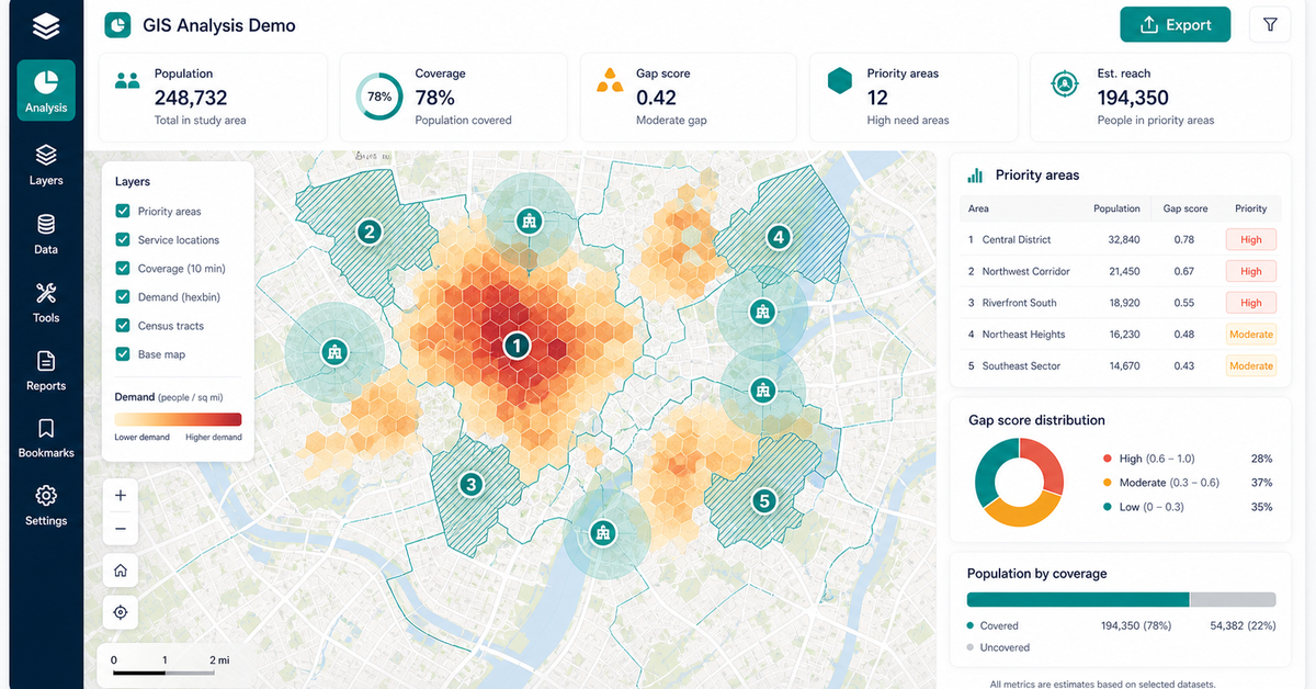
Python and GIS analysis pipelines that turn spatial data into ranked tables, exports, and dashboards.
Build out a tool, integration, or pipeline that doesn't exist in any off-the-shelf GIS product.
GIS project scoping, geospatial consulting intake, and custom map project estimate.
Map build, imagery review, field workflow, annotation, environmental report, litigation support, or automation.
Screenshots, spreadsheets, sample imagery, routes, parcels, or a written manual process are enough to start.
Scope, recommended stack, risks, proof artifact, budget range, and next decision.
Bring the closest real workflow. We map what you send, what your team reviews, what evidence stays visible, and what you receive at handoff.
Sample files, screenshots, addresses, routes, imagery, forms, or workflow descriptions.
We match the request to the closest proof surface and define what must change for your data, users, and decision.
Fit notes, risks, data-readiness gaps, and recommended proof artifact are written down.
Delivery plan, proof recommendation, booking path, or scoped build estimate.
The first review produces a practical path, not a generic sales deck.
Sensitive data can be discussed under NDA before transfer.
Sample files, screenshots, addresses, routes, imagery, forms, or workflow descriptions.
Fit review, risk notes, data-readiness notes, and recommended proof artifact.
Delivery plan, proof recommendation, booking path, or scoped build estimate.
No vague discovery phase. You bring four or five things, we return a specific plan you can evaluate.
No open-ended retainers. No "discovery phases" that bill for months without producing anything you can evaluate.
You send a data sample and a target outcome. We return a written scope, fixed price, and pilot plan within 48 hours.
A clickable web map or analysis run on a slice of your data — fixed fee, evaluable in under 2 weeks.
Full build with documentation, runbooks, and source code transfer. Deployed on your infrastructure or ours.
Recorded walkthroughs, training session with your team, and 30-day hardening period where we stay on call.
These open the real, interactive demos on our main site — not screenshots, not videos. Click around before you decide to talk to us.
Three things: a representative slice of your data (CSV, shapefile, or screenshot is fine), a one-paragraph description of what you want to build, and the names of the systems it needs to integrate with. We work from those.
30 minutes. We look at your data live, ask 5-10 clarifying questions, and return a written delivery plan with scope, fixed price, and timeline within 48 hours.
Yes — standard mutual NDA before any data exchange. We work with sensitive municipal, environmental, and litigation data routinely and our process is built around chain-of-custody.
We tell you. If you would be better served by another vendor or an in-house hire, we say so on the scoping call. We have referred work to other consultancies when the fit wasn't right.
A short path for teams that already know they need a map, imagery review, report workflow, or geospatial autom…
Start with a working map example, then talk through the data, decisions, and deliverable your team needs. We w…
Custom web maps, imagery review, field systems, automation, annotation, and decision reports for teams that ne…
Dispatch optimization, container tracking, and demand prediction built for roll-off dumpster companies — runni…
Free, 30 minutes, no slide deck. We will look at your data live and tell you what is buildable, what is not, and what a realistic timeline looks like.
Submit project context